
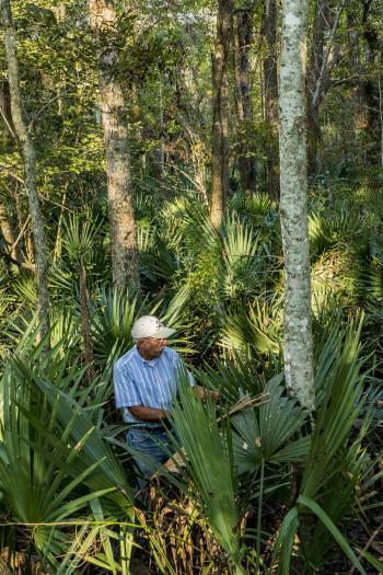
Donovan Garcia in an off-trail patch of unusually tall palmetto
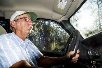
Garcia spends much time on the water and hiking trails in the Bayou Teche National Wildlife Refuge
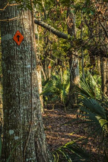
A marked trail in the refuge
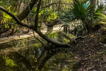
Most of the area is wetland, but trails are built on old levees
Just beyond the back door: The Trails of Franklin
Story and Photos by
ROGER EMILE STOUFF
There is a nearly invisible movement of people in and out of the Franklin area.
They go largely unnoticed, interacting mostly with those they do business with, and most often, the one guy they came here from near and far to meet.
Relax. They’re here to experience the wonders that are south Louisiana via the water and hiking trails that lie, also largely unnoticed by the local populace, just minutes from the city limits.
It’s Donovan Garcia of Jeanerette they usually come to meet. Though his name has been in the local newspaper and other media for years, his reputation has spread exponentially outward.
Garcia knows these waterways. He knows these trails. Heck, fact of the matter is, he built most of them, in whole or in part.
So west St. Mary’s best-kept secret lies all around its residents, and hoards of people are coming to see it.
Around 2003, Garcia, who has paddled watercraft since he was 12, was out in the Bayou Teche National Wildlife Refuge (BTNWR), originally created to help the preservation of the Louisiana Black Bear.
“So I was paddling around, and when I paddled down the Franklin Canal and into the Hanson Canal, I couldn’t believe where I was,” he recalls. “There I was, 40 years old, and never been down this canal. Then I come to these structures, these things, and I started doing research. (The canal) was built in 1905 at a cost of $240,000. It was the first intracoastal waterway through Louisiana. Then a guy named Morgan takes it and extends it all the way to Houston, dredges the Atchafalaya River, and they rename Morgan City after Charles Morgan.”
Since then, he’s promoted paddling, and later on, trail hiking passionately. The logistics are often difficult, but “when I see the Franklin Canal, the Hanson Canal and Bayou Teche, it’s like 10 miles. It’s a 1¼ mile shuttle from one boat landing to the other boat landing. So you could do 10 miles (paddling) and walk one mile back to your vehicle.” Other areas, in Iberia Parish and such, are much more complex and lengthy.
Garcia approached the Cajun Coast Visitor and Convention Bureau and they were interested in trail construction; BTNWR, not so much.
That changed, and the idea began to take root. Today, there are 240 miles of paddling trails in or around the City of Franklin. Seventy-file miles are offshore, Garcia said. “St. Mary Parish has the first saltwater trails in Louisiana.”
From Baldwin, paddlers can follow any number of water trails in saltwater. “You can do it so many ways,” he said. “If you start from Jeanerette, to Calumet, that’s over 60 miles.”
There’s a Bayou Teche Trail; a Grand Avoille Cove Trail; and through Lake Fausse Pointe to the Jeanerette Landing.
Baldwin can be a point of launch for upper and lower Bayou Teche; and to Burns Point or Cypermort Point.
Franklin is “very unique,” Garcia said. “Franklin should be the paddling destination of the south. You have Bayou Teche, you have Yellow Bayou…the three trails on the refuge, the Alligator, Black Bear and Wood Duck trails. Then there’s the Franklin Paddling trail that starts at the Franklin Canal, goes to the Hanson Canal and ends at Bayou Teche behind the graveyard.”
Awaiting paddlers are all of Louisiana’s wonders in an amazingly concentrated area.
Hang on: We’re getting to the hiking trails.
Where the Hanson Canal terminated to that long waterway to Houston created by Charles Morgan, was later extended to become the rest of the Intracoastal Waterway.
“The locks on the Hanson Canal were built at the same time as those on the Panama Canal,” Garcia said. “They had wooden gates, and some of the hinges are still there.” And they were literally locks, not just floodgates, allowing water to fill up or down between gates to move vessel traffic inland and out.
Some of the 240 miles of paddling trails involve dead-end waterways, so paddlers back-track to return.
About those hiking trails: Most of them are built on old levees.
“These old levees were dug by hand probably over 150 years ago” in one area in the Centerville Unit of the refuge. Farmers made levees to grow cane and pumped water out when necessary.
There are 20 miles of hiking trails outside Franklin, and 25 miles of bicycle trails.
For instance, there are two, three, for and six mile hiking trails in the immediate vicinity.
“I’m getting people from as far away as Corpus Christi, North Dakota, Florida, Georgia, North Carolina,” Garcia said. “They’re coming here. But there’s no way to track it. There’s nothing at Walmart that has anything to do with paddling, they have to go to a specialty shop to find out how many people are here doing it. But here’s what I know: If they stay here for one day and go home, they spend about $80. If they stay overnight, they spend about $200. If they spend three days, they spend between $600-800.”
The numbers drop off after that, but the advantages to the local economy are obvious.
The lack of camping facilities can be a detriment to drawing more visitors, and keeping them longer, Garcia said.
“No matter what, once we get them here, we send them away,” for camping amenities, Garcia noted.
Some local campgrounds don’t take reservations. “All of that being said, we have a lot, for having very little money,” Garcia said.
A boardwalk built by the CCVCB just off the levee past the Centerville Pumping Station on Alice C. Road gets lots of use, Garcia said. He’s seen people use it for wedding, graduation and other photographic opportunities.
Garcia has worked with five refuge managers since the BTNWR was established. The Louisiana Hiking Club took an interest in the refuge trails after participating in the Bayou Teche Bear Festival a few years ago. The club’s members helped in building trails, with financial help from business grants, the Friends of the Bayou Teche Refuge group and the club itself. “For $2,100 we built this trail, which is unheard of, it usually takes $20,000 to do this. Most of it went in building bridges,” Garcia said. “Of all the people who helped me, not one was from Franklin.”
If there was a camping area, many volunteers would stay and work much longer, he said.
Hikers should prepare for wildlife: wood/banana spiders, mosquitoes, possibly snakes and alligators, and some wet areas along the trails. Though most of the trails are atop levees, there can still be standing water. “The best thing about these levee tops is you can take your kids, and you don’t have to worry about cars,” Garcia said. “Summertime it’s going to be hot. In winter it can be real windy. “
Trails are closed from Sept. 30 to Feb. 1 each year during hunting season.
For more information about the refuge and the various trails, visit:
http://www.bayoutecherefugefriends.org/
- Log in to post comments