Morgan City levee-raising work begins
By ZACHARY FITZGERALD
zfitzgerald@daily-review.com
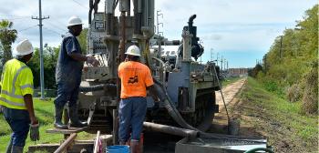
MORGAN CITY — Geotechnical engineering work began Tuesday on the Morgan City backwater levees to determine how much the levees need to be raised to certify them for flood protection.
The St. Mary Parish Consolidated Drainage District 2 contracted the St. Mary Parish Levee District to raise its levees in Morgan City. The geotechnical and surveying work contract was awarded to engineering firm T. Baker Smith, which has subcontracted the soil analysis to Eustis Engineering.
The geotechnical work, field sampling and surveying should be finished on the Morgan City levees by the end of October, St. Mary Parish Levee District Executive Director Tim Matte said.
Without improvements to the levees, the base flood elevation inside Morgan City will go up dramatically, Matte said. Some homes and businesses that were built above base flood elevation at the time they were constructed would now be below base flood elevation.
Base flood elevation refers to the elevation deemed necessary for flood protection according to FEMA’s Digital Flood Insurance Rate Maps.
Landowners with buildings below base flood elevation would be the ones most affected by flood insurance increases, Matte said. Because the city appealed the 2008 Digital Flood Insurance Rate maps, for flood insurance purposes, property owners are still going by the 1996 maps.
At some point, however, FEMA is going to declare the appeal finished, and then the majority of homes in Morgan City would be below base flood elevation, Matte said. “If you’re below base flood elevation, those are the individuals that are seeing the huge spikes in their flood insurance,” Matte said.
After completing the soil analysis, Eustis Engineering will provide the slope that the soil in the levees can support. “That’ll be one of the determining factors in exactly how high they have to build and how wide the levees have to be in order to support that height,” Matte said.
The other big change that the proposed 2008 flood maps could bring is the elimination of the grandfathering status. As it stands with 1996 maps, if property owners keep their flood insurance current, they are grandfathered in to the flood insurance rate they are already paying, Matte said.
Engineers will make calculations to determine height, width and stability requirements for the Morgan City levees. Shortly after the field work is completed, a permit application will be filed with the U.S. Army Corps of Engineers, Matte said.
Levee district consultants are going through an analysis to determine whether levee construction could have any effects on the wetlands, he said. “Any time you have a potential for impact on wetlands, you have to also make a determination if you do as part of your permit application,” Matte said.
The preliminary design work on the Morgan City levees is expected to be finished by the end of February. Once the preliminary design is approved, the final design phase will begin and probably extend through June 2014, Matte said.
The Auburn levee will likely have to be built to 8 feet tall, and the levees near the lakefront on Lake Palourde will probably need to be around 10 feet tall, he said. Right now, the Morgan City levees are anywhere from 6 to 7 feet tall, which is below what is needed to be certified for flood protection, Matte said.
The engineering work will cost about $1.1 million, and the projected cost to actually do the construction work to raise the levees is $7.2 million. The construction plans would extend about four miles from the Auburn levee to the river levee near Lake End Park.
- Log in to post comments
